Here at Worthy Go, I use GPS coordinates to ensure I can find a place, give good directions, and know exactly where on earth I am. It makes a world of difference when getting off the beaten path, especially to places where well-written directions might otherwise be lacking. Simply put, if you have the GPS coordinates to a place, you can find your way there no matter how good or bad the street addresses are.
I’m a big — nay, huge — fan of anything that makes traveling easier. One aspect of traveling that causes the most problems, at least for folks that travel independently like me, is navigation / directions. A newspaper or magazine may offer up a street address to look complete, but that’s less than helpful in some countries. Korea was great for street addresses, thanks to the excellent Google Maps app, while Thailand… has aways to go. Singapore? Good! Laos? Not so much.
Even if the street address system is good, however, there’s a huge difference between squinting at numbers on dark houses, hoping you’re going the right way, and knowing your destination is 450 meters ahead.
If you’re the sort that are already using GPS coordinates, bless you — feel free to share this article with those yet to be converted. If you’ve never used them before, consider this your introduction and call to action. You’ll also have to pardon my enthusiasm for a technology that’s simply not being used to its full potential — especially when that potential makes traveling so much easier.
Table of Contents
What does GPS mean?
GPS is short for Global Positioning System — if you’ve used Google Maps or an in-car navigation device, the GPS is working behind the scenes. If you’ve heard of geocaching, the 21st-century game that uses GPS coordinates, you probably already know what GPS is.
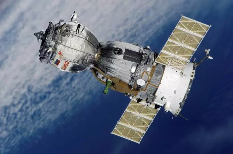
Imagine a network of satellites way up in space that orbits the earth on very precise orbits. They circle the earth twice a day, and if you were in space they might look something like this:

These satellites send the signals back down to earth, and your phone triangulates its location based on the signals from those satellites. While you’re standing there waiting for your favorite mapping app to show your location, your device is trying to lock onto signals from at least three satellites — each one moving at about 7,000 miles an hour! Once it locks on, however, those signals pinpoint your exact location to within a few meters. If you’re indoors or a dense, built-up city, you might see your location bounce around a bit while your phone tries to make sense of the signals — buildings block some of the signals.
What are GPS coordinates?
As a sphere (well, close enough), the Earth is 180 degrees from the North Pole to the South Pole and 360 degrees around. At their most basic, a set of GPS coordinates is a set of two numbers. All of these are valid GPS coordinates, and they get more precise as you go down the list:
13, 100
13.7, 100.4
13.75, 100.49
13.750, 100.491
13.7503, 100.4915
13.75032, 100.49153
13.750325, 100.491530
(Note the degree sign isn’t usually present, and isn’t necessary in most cases.)
The first number is the latitude (north to south) — 0 degrees being the equator, 90 degrees being the north pole, and -90 degrees being the south pole.
The second number is the longitude (east to west) — 0 being the prime meridian which runs through Greenwich, England. Positive numbers are to the east of the prime meridian, while negative numbers are to the west.
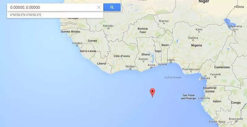
Using this system, the center of the world (0 degrees latitude and 0 degrees longitude) is in the Atlantic Ocean:

There are a couple of common ways you’ll see GPS coordinates: degrees, minutes, and seconds, and decimal format:
- Degrees, minutes, and seconds (sometimes called DMS) — just like you might remember from geometry class, there are 60 minutes in a degree, with 60 seconds in each minute. The coordinates for the Grand Palace in Bangkok, for example, are 13°45’01.2″N 100°29’29.5″E. (In other words, it’s 13 degrees, 45 minutes, and 1.2 seconds north of the equator, and 100 degrees, 29 minutes, and 29.5 seconds east of the prime meridian.)
- Decimal degrees (sometimes called DD) — add enough decimals to the degree until it’s precise enough for you (explained below). The Grand Palace in this system, for example is 13.750325, 100.491530.
Which system should I use?
Personally, I use the decimals method in posts, when I travel, and pretty much everywhere else. It’s what Google Maps shows, it’s easier to type since you don’t have to worry about North or East, and it’s easy to get really precise.
To convert from one to the other, check out http://www.gps-coordinates.net/gps-coordinates-converter.
How specific do I need to be?
This Wikipedia post breaks it all down, but let’s keep it simple here.

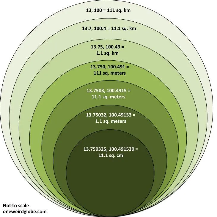
Using the following coordinates narrows a location down to different sizes:
13, 100 = 111 square kilometers — not nearly specific enough.
13.7, 100.4 = 11.1 square kilometers = still not really specific.
13.75, 100.49 = 1.1 square kilometers = good enough for a city or country.
13.750, 100.491 = 111 square meters = good enough to narrow it down within the city, but not a specific place.
13.7503, 100.4915 = 11.1 square meters = fine in rural areas, but not quite there for urban areas
13.75032, 100.49153 = 1.1 square meters = perfect for most anywhere on the planet!
13.750325, 100.491530 = 11.1 centimeters — probably a little overkill unless you’re referring to a very specific part of a building.
If using minutes and seconds, the first decimal in the arc-seconds narrows the exact location to about three meters — good enough to tell one building from the next in most cases.
Why are GPS coordinates better than street addresses?
The simple answer is that a street address is only as strong as the system it’s tied to. In the Western world, the street address of 123 Main Street implies it’s between 121 Main Street and 125 Main Street. (122 and 124 are on the other side of the road.) This system works, so long as they’re in the correct numerical order and you know where you are along Main Street. This isn’t always the case — in Thailand, for example, houses aren’t consistently numbered, and rural roads often lack the signage to help you know what road you’re on!
GPS coordinates end up being far more useful in areas that lack an address system (such as a hiking trail or an area in the water). They give an absolute point of reference to a very specific place on the planet, and don’t rely on streets or landmarks to help you find your way. Your mapping app uses the streets to make directions, but that endpoint is determined by the coordinates, not an address.
OK, so they’re better — so how do I use GPS coordinates while traveling?
Scenario A: you’re meeting a friend at a brand-new coffee shop. (Mmmm, coffee…) It’s not yet listed on Google Maps, but your friend has the GPS coordinates. She sends them to you via e-mail or text message, and you paste or type them into Google Maps. The app brings up the shop’s exact location, and off you go.
Scenario B: you’ve discovered a magical new coffee shop that has their GPS coordinates listed instead of a street address. Apparently, it’s kind of hidden behind another building, so they say ‘look for this building’ and offer their coordinates.
Scenario C: you beat your friend to the coffee shop (noticing a theme here?), so it’s time to find your current GPS coordinates to ensure your friend can find the same place. Google Maps makes it easy to send your location from either platform (zoom in, then tap and hold on your location. Tap ‘Share’ and choose how to share your location. The map will have the GPS coordinates encoded in the link.
Scenario D: you’re on your way to, say, a remote Buddhist temple (yeah, can’t keep up the theme, sorry). Using the coordinates that are part of the post, Google Maps knows exactly where you want to go, and can plot directions for you on the fly.
How do I find my GPS coordinates while traveling?
I’m so glad you asked.
On your iOS device: Turn on Location Services if it’s not on already (Settings > Location Services > On). Ensure that Location Service for the Compass is on, then hit the Home button and open the Compass app. After ‘calibrating’ it by rolling the ball around the circle, the phone will display your current coordinates in arc-minutes format. Tap those coordinates to bring up the Apple Maps app, or
On your Android device, open the stock Compass app (if your device has it) or use a free app like Compass to help. In Google Maps, once the app has found you, tap and hold on your location to bring up the menu. Click ‘Share’, then choose to send an e-mail or SMS text message. The map will have the GPS coordinates encoded in the link.
On either platform, a free app like Glympse (Android | iOS), One Touch Location (Android | iOS) or other location-sharing apps work with your GPS coordinates behind the scenes. In essence, they share your location to the friends or family you choose.
On a stand-alone GPS device, read the manual or look through the menu. Some make it easy to see your current location, while others focus on directing you from point A to point B.
What are the drawbacks to GPS?
You won’t have the excuse of ‘I couldn’t find the place’ anymore — assuming you’ve been given accurate coordinates in the first place.
If you’re local to an area, a street address will make more sense to you. Hearing about the barbershop that’s near the Target along Patton Avenue automatically brings a picture in your head about where that barbershop is. Hearing that the barbershop is at a series of coordinates can’t do that.
A typo in the GPS coordinates can put you on a different street — or country. Double-check the GPS coordinates to ensure they reflect reality, or at least the correct city.
A GPS address remains rather abstract. Even if you know your current GPS coordinates, guessing the distance from here to there can be difficult. It’s hard to know whether, say, 37.193759, 102.450284 is in your backyard or halfway around the world.
You’ll need a smartphone, 3G tablet, or GPS device — but it doesn’t necessarily need to be online.
With that said, I’m still a huge fan of GPS coordinates — and you will be too.
Start by tapping or clicking the links on the posts here at Worthy Go. Ask for GPS coordinates when you can’t find a place.
Any questions about GPS coordinates? Comments are open.


